Lesson 8: Culture in North America
You've drawn some maps and learned a little bit about North America. Remember you're going to have to memorize the countries and capitals when you take the test before winter break at the end of the semester. I listed all the countries in North America for you in Lesson 5. Let's talk about capitals for a moment.
If capital is spelled with an 'AL' then it is the chosen as the 'most important city' in that country. It isn't necessarily the most populated, but it was chosen as the most important. If capitol is spelled with an 'OL' then it is usually referring to a building.
So the every state in the United States has a capital. But the states in the United States aren't countries so we're not going to talk about them in this course. The country of the United States has a capital. It's WASHINGTON D.C. (which is on the east coast by Maryland)
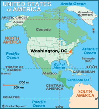
Washington D.C. is not considered part of a state, because some people think it wouldn't be fair that one state gets the most important city in the United States. D.C. stands for 'District of Columbia' so it is technically considered a 'district' not a state. And don't confuse it with the STATE of Washington which is on the West Coast. Here's a short video about our nation's capital:
I was able to visit Washington D.C. this last spring and it is amazing. If you ever have the chance to go, I would recommend it.
The United States is just one of the countries in North America. And all of the countries have a different culture and feel about them. I wish we could study in detail every country in the world, but alas, there isn't time. I do want to talk a little bit about them though.
This is one reason why I am such a fan of traveling. When you think about another place you usually have a few ideas. For example when you think of Canada you might think about these things:

|
|
|
|

|
Things like these are stereotypes. Some are true and some are exaggerated. The best way to learn about a place is to actually experience it. There's also the stereotype that Canadians are extremely polite and nice. This picutre implies that even when there is a riot, they are polite:

The United States shares its border with Canada. Watch this humorous video about a man who works for Canadian Border Patrol
The sketch tries to be funny by drawing on a few stereotypes that exist about Canada:
-Canada is Cold
-Canadians don't have a need to cross the border, therefore there only needs to be 1 man to patrol the border 'Canada is not the threat that it once was'
-Canadians are friendly and polite
When you learn about a place it is hard not to draw on stereotypes like this, because it is what you have heard and what you remember. The stereotypes that exist for Canada, for the most part, are more positive than they are negative- which makes it a good country to study the effect of stereotypes. The best way to find out if a stereotype is true or not is to look at facts. What is the average temperature in Canada? Are different parts warmer than others? Is there statistical evidence proving that these stereotypes are true?
Here is a little more about Canada. The captial of Canada is OTTAWA:

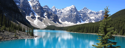
Just like Washington D.C. is for the United States, Ottawa is the center of government for the country of Canada. It is the fourth largest area in Canada with 1.2 million people. The official languages are English and French.
City of Ottawa, Canada
Watch this video, it is an advertisement trying to draw tourists into Canada:
So far we've covered a little bit about the United States' capital and Canada. Let's look at other countries that are part of North America. The United States shares its southern border with Mexico. Mexico and the countries south of it are considered an area called 'Latin America'.
Latin America refers to countries and territories that speak Spanish and Portuguese. This includes parts of South America, but we'll talk more about the countries in South America in Lesson 10.
When you're learning about a country it is important to look at a lot of different aspects. I mentioned how travelling to another place helps you understand that place better, but you still have to be careful when forming opinions. When you go to Mexico for example, there are a lot of places that are designed for tourists, but that isn't necessarily what Mexico is all about.
If you have taken a World History class chances are you have learned about the Mayan and Aztec civilizations. It's a pity that we don't have time to go into the rich cultural heritage of Mexico, or most of the countries of the world. Studying history can help you understand why a country is the way that it is. People in Mexico speak spanish because spanish conquistators (conquerors) conquered Mexico in the 1500's. The Spanish (who came from Spain which is part of Europe) conquered many countries in that region. They were all over.
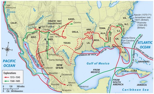
Spanish Exploration in North America
Today when you say that someone is Spanish or Hispanic you aren't necessarily talking about the European Spanish who live in Spain. It could mean people from Latin and Central America who speak spanish and share some of their cultural heritage with Spain.
The capital of Mexico is Mexico City:

When you're studying other nations you can look at so many different things:
What are some of their traditions?
How do they celebrate holidays?
What kind of food do they eat?
How do they view their ancestors?
What religions are dominant in the area?
What do they do for entertainment?
How do they view foreigners?
What are some important landmarks in the country?
How do the people of the country view their history?
What kind of music do they listen to?
What values are important in their culture?
You can take courses on how to study different cultures and how they devleop... ANTHROPOLOGY. It is interesting stuff.
So far I've only given you a brief outline of 3 of the countries in North America. I wish we could talk in more detail, but like I said there isn't enough time. You could take an entire class on one country so it is crazy to try and fit the most important things about a country in a lesson with 20 other countries.
We'll go through the other countries in North America pretty quickly...
We can't forget GREENLAND which is a country North East of Canada. It used to be part of Denmark until about 35ish years ago. Its capital is Nuuk:
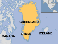
You'll notice that Iceland is right next to Greenland. Iceland is also a country, but we're going to consider it part of Europe so you won't need to study Iceland quite yet.
Now lets go south to Central America. Central America is the isthmus that connects Mexico to South America.

I'm actually going to save talking about Central America for a future lesson... so let's move on to the islands east of Central America which is commonly known as the Caribbean.
Watch this video about a 25 islands in the Caribbean:
Assignment 8
To help you prepare for your Mid-Semester Map Test for this assignment I'm going to have you make a study guide. Remember you're going to need to know both the names of the country AND their capitals. For you to study and memorize these the best way is to first label them yourself. Print out this map:
| blank_map_north_america.docx |
Label Canada, Greenland, the United States of America, and Mexico. Then label their capitals: Ottawa, Nuuk, Washington D.C., and Mexico City.
Next download and print this map:
Next download and print this map:
| blank_map_central_america.docx |
I know you already printed and labeled a map in Lesson 5, but these two maps are the actual maps I'm going to use for the test, PLUS the more you write it down the better you'll remember where the countries are and what their capitals are. Repetition is the key to success! Okay that may not be always true, but in this case repetition is helpful. It isn't too much work to label countries. AAAANND back in Lesson 5 I had you look up all of the capitals. This time I'm going to tell you what they are, so if you got them wrong in Lesson 5 you'll have this map (which will be correct) to study from.
For the 'Central America' map you just downloaded (remember in this case we're counting Central America as part of North America) you need to label these countries:
Guatemala and its capital Guatemala City
Belize and its capital Belmopan
El Salvador and its capital San Salvador
Honduras and its capital Tegucigalpa
Nicaragua and its capital Managua
Costa Rica and its capital San José
Panama and its capital Panama City
Cuba and its capital Havana
Jamaica and its capital Kingston
Haiti and its capital Port-au-Prince
Dominican Republic and its capital Santo Domingo
At this point there isn't going to be enough room to label the capital in the right place, so just draw an arrow to the country you're labeling and write the capital next to it.
St. Kitts and Nevis and its capital Basseterre
Antigua and Barbuda and its capital St. Johns
Dominica and its capital Roseau
P.S. Martinique is considered a part of FRANCE so you don't have to label it, it's not an 'official country'
St. Lucia and its capital Castries
Grenada and its capital St. George's (yes with the apostrophe)
Barbados and its capital Bridgetown
St. Vincent and the Grenadines and its capital Kingstown (kind of like Jamaica's capital but spelled different)
Trinidad and Tobago and its capital Port of Spain
The Bahamas and its capital Nassau
Also label or highlight:
Atlantic Ocean (already labled but highlight it so you know to study it for the test)
Pacific Ocean
Gulf of Mexico (also already labled but highlight it so you know to study it for the test)
Hudson Bay (this one you'll have to label on the first map)
Standard 2 Objective 1 A
